 vesseltracker.com
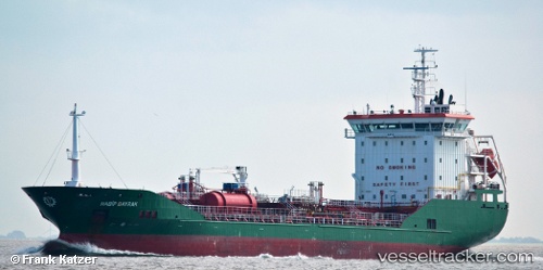
Vessel HABIP BAYRAK IMO: 9458183, MMSI: 229674000 Chemical/Oil Products Tanker
UTC, 35.26667, -2.84833, course: -1, speed: 0
UTC, 35.28771, -2.91311, course: 280, speed: 1.4
2026-02-17 07:46:26 UTC, 35.27914, -2.91546, course: 338, speed: 0
Live AIS position:
UTC. Near NADOR),
updated 2026-02-17 07:46:26 UTC.
Find the position of the vessel HABIP BAYRAK on the map. The latter are known coordinates and path.
marine traffic ship tracker show on live map
The current position of vessel HABIP BAYRAK is 35.27914 lat / -2.91546 lng. Updated: 2026-02-17 07:46:26 UTCCurrently sailing under the flag of Malta
HABIP BAYRAK built in 2010 year
Deadweight:
8405 tDetails:
Last coordinates of the vessel:
UTC, 35.26667, -2.84833, course: -1, speed: 0UTC, 35.26667, -2.84833, course: -1, speed: 0
UTC, 35.28771, -2.91311, course: 280, speed: 1.4
2026-02-17 07:46:26 UTC, 35.27914, -2.91546, course: 338, speed: 0